


News and Updates
New Community Features
Anniversary and a Major Update for Wingit on Web
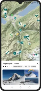
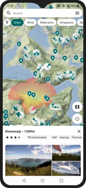
Plan Adventures around 26.000+ Flying Sites Worldwide
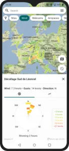
Live Conditions from 9.000+ Weather Stations, Rain Radar, and Webcams Worldwide
Monitor the Skys with SafeSky Live Tracking
SafeSky is also a technology leader around the anticipated U-space, a future airspace for civil drones, ensuring that you'll be able to see drones and drones will be able to see you.
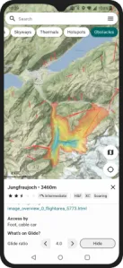
Safer Flying with Global Glide Range Coverage and Obstacles*
When calculating your range, Wingit will download a slice of the elevation model onto your device enabling offline re-evaluations for spots nearby. This means that once out and about, you can always check other takeoff options given the conditions without relying on a connection.
* Obstacles are currently available in Switzerland only.
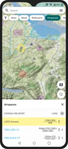
Airspaces and Airports Worldwide
Tapping the map, Wingit shows you the vertical structure allowing you to better understand the layering and to find that corridor. Airspaces are updated every few hours automatically based on above providers. We cannot no guarantee their correctness or completeness. Always check with your local authoritative sources before takeoff.
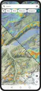
Skyways, Thermal Maps and Thermal Hotspots
Frequently Asked Questions
Wingit is a free Android and iOS App aimed at Paragliding pilots. The goal is to offer a one-stop shop for pilots planning their flying adventures. The app works globally and is optimized to work well on spotty connections or offline as your reliable companion wherever you go.
Organizationally, Wingit is a free, at-your-own-risk, and non-commercial passion project. If you're interested in learning more or supporting the mission reach out to [email protected].
From a wide variety of sources. Credit where credit is due:
- Maps from:
- Flying sites are sourced from:
- Live Tracking is provided by SafeSky.
- Airspaces from OpenAIP and SHV/FSVL (CH).
- Webcams from Windy.
- Wind data from:
- Forecast from Paraglidable.com.
- Rain radar from RainViewer.
- Skyways and thermal data from KK7.
- Hiking routes through OSRM.
- Digital elevation model from Viewfinder Panoramas.
- Obstacles from BAZL.
Wingit respects your privacy. It neither collects your data nor does it track its users. Most of Wingit's functionality is freely available w/o any form of identification or authorization. Check out the privacy policy for a more buttoned-up version.